Kirra Point Groyne Coastal Impact Study
In March 2010 the Tweed River Entrance Sand Bypassing Project (TRESBP) commissioned the Kirra Point Groyne Effects Study. The purpose of the study was to undertake a desktop investigation of the expected impacts of Kirra Point groyne on the shapes and widths of Kirra, Coolangatta and Greenmount beaches, and on the exposure of Kirra Reef now the project is delivering natural quantities of littoral drift sand to Queensland. In addition, potential changes to sand movements and possible inundation effects on Kirra Reef were investigated in response to two hypothetical scenarios: 1) adjustments to the length of Kirra Point groyne (including both lengthening and shortening the groyne); and 2) the complete removal of the groyne.
The Effects Study used a qualitative approach based primarily on the analysis of aerial photography to describe sand movements during three time periods. These periods included: pre-1960s (prior to both the construction of Kirra Point groyne and the extension of the Tweed River training walls); 1972-2001 (after both the construction of Kirra Point groyne and the extension of the Tweed River training walls); and 2009 onwards (after approximately eight years of operation of the TRESBP).
A copy of the Effects Study can be viewed here (PDF 3.79MB) and a summary table is presented below. In addition, the project has compiled a history of vertical aerial photography for the Kirra Point region taken from the 1930's through to 2011, although available historical aerial photography from the 1930s to the 1960s is very limited in extent. A summary of the aerial photography relevant to discussions presented in the Kirra Point Groyne Effects Study can be viewed here (PDF 3.3mb).
As indicated above, the Kirra Point Groyne Effects Study was prepared using a desktop approach and historical data. The findings of the report should be regularly verified against observed behaviour and as the TRESBP continues to deliver sand to match the natural littoral drift rate there may be an opportunity to review the outcomes of the Impact Study in the future.
It is also important to note that the Kirra Point Groyne Effects Study does not form part of a management strategy for Kirra Point Groyne. Decisions regarding the groyne are the responsibility of Gold Coast City Council (GCCC) and the Queensland Department of Environment and Resource Management (DERM).
Kirra Point Locality–Beach and Reef Exposure Changes Summary Table
(Adapted from the Kirra Point Groyne Effects Study)
Physical Aspect | Pre 1960s Pre Tweed Breakwater Extension (Natural Condition) | 1972–2001 Post Kirra Point Groyne Construction Pre TRESBP Operations (Depleted Sand Supply Condition) | 2009 onwards Post TRESBP Operations (Restoring Natural TRESBP-Sand Supply Conditions) |
|---|---|---|---|
Sand movements Point #1: Beach conditions are a result of wave conditions (such as ocean storms), sand transport rates and the impact of the headland and/or Kirra Point groyne on sand movement. Point #2: The locations of shorelines around offshorhe bars have varied over time in response to changing sand movements and wave conditions. |
|
|
|
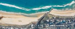
4 January 1955
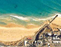
5 April 2010 | 6 May 1982 | ||
Reef Exposure Point #3: Exposure of Kirra Reef is strongly linked to beach widths, littoral zone widths and offshore seabed levels. Point #4: All of these aspects are, in turn, affected by variations in the volumes of sand being transported along the coast. Point #5: The presence of Kirra Point groyne also has the potential to affect sand coverage on Kirra Reef. |
|
|
|
 2 April 1946
12 October 2009 |
24 July 1996 | ||
Effect of Kirra Point groyne on sand movements and reef exposure Point #6: Generally, the groyne affects the positioning of the updrift(Coolangatta–Greenmount) beach system, including the beach bar that extends between Coolangatta Beach and Kirra Beach. | Not Applicable |
|
|
Effect of extending Kirra Point groyne Point #7: Generally, the updrift (Coolangatta–Greenmount) beach system, including the nearshore bar, moves offshore | Not Applicable | Not Applicable |
|
Effect of removing/shortening Kirra Point groyne Point #8: Generally, the updrift (Coolangatta–Greenmount) beach system, including the offshore bar, moves onshore. | Not Applicable | Not Applicable |
|